I love maps and the things one can learn from maps (you can probably blame J.R.R. Tolkien and Frank Herbert for that one). Imaginary maps, historical maps, contemporary maps all fascinate me. As I child I drew my own in complex and intricate detail, much to the chagrin of my father and grandmother who found me an awkward non-conformist anomaly in their lives. Around the age of twelve I began working on a series of charts, elaborately illustrated, to accompany and tease out a body of stories that I was writing as part of a fantastical world of my own creation. I dubbed the tales the “Otherworld Cycle”, with inspiration drawn from Irish and Celtic mythology and a nod an’ a wink to Tolkien and company (I recently went looking for those maps and was saddened to realise that somewhere along the way they had been lost).
Perhaps another reason for my cartographic interests was my Irishness. I grew up in An Pháil “The Pale”, the region around Dublin city that had once been the bastion of Britain’s colony in Ireland. Much of this changing area had been defended in the Medieval period by an elaborate network of banks and ditches, walls and palisades (hence the Pale). It was our own extremely modest – and unwelcome – Great Wall of China, though little of it now survives. On one side were the British settlers; on the other the natives – i.e. the Irish (and some argue that is still the situation).
Of course things were far more complex than that during the Middle Ages. The population beyond the Pale (recognise the expression?) was in fact a complex one: overwhelmingly Native Irish with smaller communities and families of Scandinavian-Irish, Norman-Irish and Anglo-Irish origin. Most of these “foreigners” had been thoroughly assimilated over the centuries, becoming Níos Gaelaí ná na Gaeil féin “More Irish than the Irish themselves”. Irish-speaking and Irish-thinking. Outside of the Pale isolated islands of Englishness did exist, areas that waxed and waned with the changing political and military fortunes of the times. Most hugged the coastlines or lived a paranoid existence at strategic points around the country, river crossings and the like, always wary of the “mere Irish” (mere means “pure”, in contrast to the mixed blood of the Norman-British and Anglo-British settlers, some of whom, after a century or two, could be barely distinguished in speech or customs from the indigenous foe).

Inside the heartland of the Pale old and new ethnicities blended together, so that the Irish language and culture remained native to Dublin and its hinterlands long after English became the language of officialdom and the culture of “polite” society. Irish-speakers may have been the hewers of wood and drawers of water but some of their supposedly English masters were not too far away from them in language or blood.
The area around Dublin abounded with “Marcher Lands”: disputed territories and buffer zones between native and invader. My own family’s ancestral lands, Muintir Thadhgháin, lay in one such region far to the south-west. There the ancestors contested with Norman-Irish, Anglo-Irish, English and at times fellow Irish in a centuries-long struggle for survival that eventually saw their kingdom collapse. It was Oliver Cromwell and his captains who divided my “home” amongst themselves, spoils of war doled out to soldiers-cum-settlers in a style that the Roman legions would have recognised.
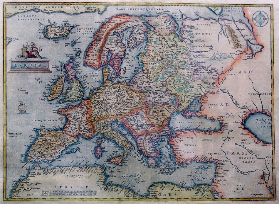
Look at any map of 14th or 15th century Ireland and one’s head would spin when faced by the fluid layers of claim and counter-claim, of pure ethnicities and mixed ones, of competing lordships and territories. At times the English are in the ascendancy and one wonders how the Irish managed to fend them off for so long. At other times the Irish are masters of all that they purvey, the map is “green” and the English colony is reduced to a desperate, tattered remnant begging England for succour. And one wonders: if only…
Yet, there was no “if only” or at least not until much, much later. Even then it was not to be the future many wished and dreamed of. For there remains in the north-east of the island the last diminished part of Britain’s colony in Ireland: a veritable Northern Pale. While elsewhere the armed settlers gradually succumbed to the allure of Irishness, the latest “planters” in Ulster resisted assimilation through the twins barriers of language and religion. And so another British border was imposed in Ireland, and like all the other British borders before it the line wound broken and crooked, a meaningless marker that was more provocation than demarcation.

So to the present day and some interesting comparisons from contemporary Europe on borders and the varied legacies of European history, presented in cartographic form. Have you heard of the small town of Baarle? It’s a Dutch town. It’s also a Belgium town. Confused? Enclaves of the World provides an explanation:
“Europe and perhaps the world’s most famous enclaves are the municipalities of Baarle-Nassau and Baarle-Hertog. These are located on the border between The Netherlands and Belgium south of the Dutch city of Tilburg. Baarle-Hertog consists of 22 Belgian exclaves surrounded by Dutch territory. These cover a total of 2.34 km² and have a population of about 2,200.
Baarle-Nassau consists of eight Dutch exclaves, seven of which are embodied within the Belgian exclaves of Baarle-Hertog. These enclaves within enclaves are known as counter-enclaves. The eighth enclave is situated in Belgium just south of the border, north-west of Ginhoven. These cover a total of 0.15 km² and have a population of about 130 engaged mostly in agriculture. Tourism has become the major economic activity in the village areas with increasing numbers of people attracted to Baarle by the complexity of its borders. To make the enclaves’ borders more visible to the visitor, metal disks have been fixed to form dotted lines on the roads. The boundaries on the footpaths have been delineated by grey stones with inset white crosses.
Baarle’s intricate enclave situation developed in the thirteenth and fourteenth centuries when the area was primarily used for agriculture with many of the parcels relating to paddocks and crops. Since then, the Baarle landscape has gradually changed to be more urban and former fields have been replaced with houses, fences and roads. This often occurred without regard to the actual boundaries between Baarle Hertog and Baarle Nassau. It appears that it was often easier to establish developments in an orderly fashion rather than to fit the convoluted enclave framework. Today many of the properties do not align with the borders but rather conform to more sensible and practical street designs. It follows that many properties are bisected by what are now international boundaries leading to a range of potential administrative problems. In these cases, a practical outcome has been to allocate nationality based upon the country in which their front door is located. This, however, has lead to homeowners blocking doorways and opening new ones in order to seek some advantage from the alternative jurisdiction. And there are those who exploit the ambiguity of having their front door positioned so as to be divided by the frontier.”
Fantastic! If ever a place appeals to the carto-nerd in me Baarle is it (“carto-nerd” is my own invention, by the by. I don’t expect it to catch on…). I love all these Ruritanian-style territories in Europe (and yes, I’m a big fan of the Andorras and San Marinos too. Sad, I know). I blame, in this case, an Irish-American writer: Leonard Wibberley and his classic Cold War satire The Mouse that Roared. Seeing the masterful Peter Sellars in the movie of the same name didn’t help either. I don’t think the book, and its sequels, are in print anymore which is a shame. Dated though they were they were also wonderfully written (or at least so they remain in my memory and who am I to gainsay that?).
How about this one?
“The Vennbahn is a Belgian railway line that cuts into German territory south of Aachen between the towns of Rötgen and Monschau. Because Belgium owns the land that the railway is on, it effectively separates five pieces of land from the rest of Germany. Typically this separation is only the width of the railway corridor.
The enclaves are called Munsterbildchen, Rötgener Wald, Rückschlag, Mützenich and Ruitzhof. Between 23 and 29,000 people live in the enclaves.”
German communities used to be found all over central and eastern Europe (sizeable chunks of modern Poland were “German” until 1945), in part as remnants of the Holy Roman Empire – the Germanic one, that is. They still survive in some places:
“Büsingen is a German exclave within Switzerland along the Rhine near Schaffhausen. It covers 7.6 km² in area and contains a population of about 1,500 people. Büsingen has a mixed economy including service-related activities in the built up areas and agriculture.
In 1967, a nearby German enclave called Verenahof was transferred to Switzerland. Verenahof was a tiny enclave of 43 hectares containing just three farms with all residents being Swiss nationals. The transfer only occurred following numerous attempts since 1815 by Switzerland to acquire the territory.”
There is much more on Enclaves of the World along these lines if your interest is piqued (in which case you should probably pop out and purchase “Vanished Kingdoms: The history of half-forgotten Europe” by Norman Davies which explore’s related themes. I cannot recommend it highly enough). You can also check out Jan. S Krogh’s very similar site too.

That was so good and interesting, and reminding me of the “Mouse that Roared” made me laugh 🙂 I have it on dvd. I love all these little glitches in borders, instead of the normal ruler- drawn Empire borders.
LikeLike
Thanks for the Comment, Joe, and I quite agree. An enjoyable book and movie (and Peter Sellars is always wonderful – well, except perhaps for “The Fiendish Plot of Dr. Fu Manchu”!). I’ve been fascinated by the Ruritanias of European history, real and imagined, since I was a child and border glitches fit right in.
I view such places the way we view natural habitats. Something to be protected and indeed celebrated. Vive la différence! 🙂
LikeLike
Especially 2:50 — 5:10
http://www.primewire.ag/watch-26866-The-Mouse-That-Roared
I love the gag where they’re speaking French in the port and it’s subtitled, and then when they switch back to English they keep the subs going for a while, and you’re still reading them … well I though it was funny first time around but I was still quite young at the time 🙂
LikeLike
Ah, I will watch that later. As a kid I was fascinated by the remnants of the Holy Roman Empire and the multiplicity of territories and various marchlands of Europe. Borders fascinate me where they don’t follow the stereotypical modern view of them. Enclaves, exclaves, city-states, etc. are cool. Or that could just be me 😉
LikeLike